| In accordance
with their Shoreline Management plans for the Lune Estuary and the
eastern shores of Morecambe Bay, Lancaster City Council wished to
undertake numerical modelling of the natural processes affecting evolution
of the shoreline habitat. The purpose of the exercise was to assess
sustainability and environmental impacts of various options for coastal
management.
Hydrosurveys were commissioned
to undertake a comprehensive survey and data-gathering exercise,
providing raw data on tidal, fluvial and sedimentary processes.
An ecological mapping study was also undertaken to assess the status
of inter-tidal habitats and communities, including vegetation, invertebrates
and bird populations.
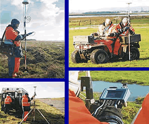
A series of ten water data recording
stations were set up at strategic locations along the estuary and
offshore, for continuous monitoring of tide and wave activity, currents,
suspended sediments and salinity
With many parts of the project area
characterised by soft mud and shifting sands, this difficult working
environment required a range of different techniques to gain access
to instruments in remote locations. Several different types of mounting
structure were tested to ensure that recording equipment would remain
in position for the duration of the study.
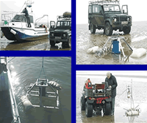
In some locations, the instruments
were maintained and calibrated in-situ by taking advantage of short
periods of tidal exposure. In others, where the instruments were
permanently submerged or on muddy substrate, the platforms were
raised periodically onto the vessel for maintenence, and then relocated
using specially adapted lifting and positioning gear.
|
|

The project has involved a multi-disciplinary
team covering topographic and hydrographic survey, ecology and
data instrumentation.
The first task was to produce a 3D
digital terrain model of the estuary and offshore approaches,
including the river channel as far upstream as Lancaster with
adjacent tidal marshes, seawalls and shipping channels. This required
fully integrated topographical and bathymetric surveys covering
an area of approximately 4000 ha and using techniques suitable
to gain access to all types of terrain. The model included areas
of low lying agricultural lands reclaimed from the sea at various
stages over the last century.
The terrain model will be used for predictive studies of channel
evolution, erosion and accretion, and to assess water levels and
coverage under different shoreline management regimes.
|